Recent satellite images taken by US-based operator Maxar Technologies show the development of a new village by China along the contested Himalayan border that it shares with India and Bhutan. Bhutan, however, has steadfastly denied these claims.
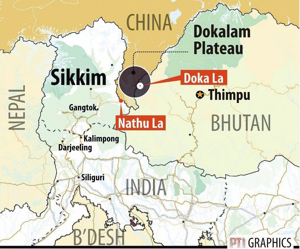
The neat cluster of houses by a stream, which is being referred to as the Pangda village, is located 9 kilometres from the Doklam plateau—which is strategically important to India and was also the site of conflict with China in 2017, when Indian and Chinese troops engaged in a 73-day stand-off, triggering fears of war at the time. Since then, this is the first construction that has been noticed in the region, and India has claimed that it lies at least 2 kilometres within sovereign Bhutanese territory. Ambassador Vetsop Namgyel, the Bhutanese Ambassador to India, has refuted the claims, saying that “there is no Chinese village inside Bhutan”. Chinese state-owned media has, as expected, dismissed India’s accusation as well, and released pictures depicting the newly built village to be within Chinese territory, although the legitimacy of the claim is disputed.
Chinese media house Global Times asserted that the Pangda village “is within the Chinese territory, inside the region of Doklam,” and it cannot “be distorted by external forces”. It also referenced open records and claimed that authorities in Yadong county of Southwest China’s Tibet Autonomous Region have confirmed that 27 households with 124 people voluntarily moved from Shangdui village of Duina prefecture of Yadong county to Pangda village in September 2020. The Yadong county is situated on China’s southwestern border, south of the middle section of the Himalayas. It borders Tibet’s Chumbi Valley and Bhutan’s Ha Valley on the east and south, and India’s Sikkim on the west. This makes Doklam strategically important to all three countries, as it lies at their trijunction.
In June of 2017, China and India were engaged in a two-month-long standoff in Doklam, which was viewed as the most serious skirmish since the 1962 War. It was triggered when China was yet again accused of constructing roads in the region, which India and Bhutan collectively objected to. The standoff resulted in a number of casualties on both sides. China has been trying to amp up its military presence in the region because it would give them easy access to the vulnerable and narrow Silguri Corridor and the Chumbi Valley, where India currently has terrain advantage.
This latest move is particularly worrying for India because Article 2 of the 2007 treaty that it signed with the landlocked nation makes India responsible for Bhutan’s defence, considering its limited armed forces and defence capabilities. Despite several rounds of negotiations between India and China to end the dispute, talks have consistently failed as neither side has been able to reach an agreement on the full de-escalation of forces. Yet, both nuclear powers continue to modernize their defence forces and arsenal.
Concerning Bhutan-China bilateral relations, the two do not share an official diplomatic relationship and communicate with each other through their missions in New Delhi. Both have held at least 24 rounds of high-level talks on the contentious border, which have repeatedly failed to produce a resolution of the conflict. China’s claims over Bhutanese territory stem from their accession of Tibet and have mostly been baseless. With the lack of a mutually acceptable resolution, all three neighbours continue to be locked in frequent and tense escalations.
Despite Bhutan Denial, Satellite Images Show Construction of Chinese Village Near Doklam
Although authorities in Bhutan have denied the development of Chinese construction in its sovereign territory, satellite images depict a Chinese-built village 2km within Bhutanese territory.
November 26, 2020

SOURCE: PTI
